
.svg)
What do the Rangitahi street names mean?
A strong connection to the land and earth has been a key value for the family since day one of bringing the Rangitahi project to life.Here are two ways that are currently supporting this vision and intention. One being the Rangitahi street names and the other is our protected and researched archeological sites within the peninsula.Using the Maori language as place names keeps the language alive in our community and our country.
By referencing the history of the land and using the Maori language, we can tell stories and encourage people to engage with the Maori language and local history as one. Tainui Hapu have chosen these street names to connect our community with the land and sea.
The ‘Rangitahi’ bridge crosses the Omahina waterway where the connection to Opotoru ends. Opotoru represents another area of the harbour, so it makes sense for the Bridge road to be called Rangitahi/ Rangitahi Road, referencing the land and starting this new journey onto the land. ‘Rangitahi Road’ - The ‘spine ’of the Peninsula. Rangitahi is the name of the land historically and the name of the family project. The Rangitahi Road starts from the Rangitahi bridge and is the gateway to the peninsula.This name is synonymous with the land and starts from the bridge along the ridges of the peninsula.

Let's look at some of these given names in more detail:
‘Pekapeka Street’- The New Zealand native Bat. Historically has lived on the peninsula.
‘Omahina Street’ - Omahina is the name of the waterway and creek connecting with the inner harbour on the western side of the peninsula between the peninsula and the golf course. This Street name can continue through stage two and follow the waterway inland.
‘Kōtare Street’ -The kingfisher. Nesting in the area is still prevalent as you cross the Rangitahi bridge.
‘Hapuapua Street’ -The greenery of the Manuka Brush, historically the people would bundle it with the Harakeke to lay on the harbour bed as a bridge to cross over to the other side.
‘Kānuka Lane’ - A New Zealand native tree prevalent on the peninsula and visible from this road in the future.
‘Te Huinga Lane’ - Te Huinga represents an area in the harbour just off the northeastern side of the Rangitahi peninsula where the tide currents/waters meet at half tide. The road looks out at this part of the harbour.
‘RewarewaLane’ - New Zealand native tree present on the peninsula and will be planted as street trees.
‘Tī kōuka Lane’ - New Zealand Native cabbage tree. The road looks down the wetlands at a lot of Cabbage trees.
‘Rātā Lane’ - New Zealand Native tree. Prevalent in Raglan.
‘MāraKaiLane’ - Referencing the land that it crosses that has been used as a community vegetable garden over the past 20 years by the families that live on the peninsula.
We are grateful to the local iwi Tainui Hapu for their amazing knowledge of the area to come up with suitable street names that have such cool meanings to the peninsula and the people.

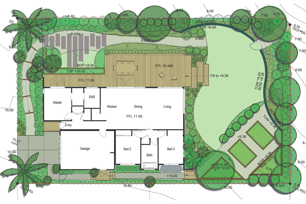
Did you know we have identified six key areas within the Rangitahi peninsula as archaeological sites?
While these valued pieces of land can not be built on, they are here to be enjoyed by all. What a great little spot to bring your picnic basket and enjoy the view like our ancestors did way back!We have plans to signify those six spots with bespoke local art and signage too, making it easier to spot them as you explore the Rangitahi peninsula. Despite the lack of systematic survey a large number of sites have been recorded in the New Zealand Archaeological Association's Site Recording Scheme (the national database of archaeological sites).
There are 229 archaeological sites recorded around the shores of Raglan Harbour (Whaingaroa). Of these, site type "Midden/oven" forms the largest subset with 84 known. "Pit/terrace" type sites are also well represented, with 78 known. Thirty-five paa are recorded, and the rest are a scattering of other types including flax milling, fishing sites and trackways. The large number of midden, pit, terrace and paa sites recorded around Raglan are evidence of sustained occupation by pre-European Maori in the landscape surrounding the harbour. Even given the incomplete record of archaeological sites, it is clear that the coastal areas around the harbour were densely settled in pre-historic times. The inlet areas with large mudflats were rich sources of fish, shellfish and birds, and they provided safe harbours for canoe travel on an otherwise wild and dangerous coastline.- Excerpt of the 2014 Archaeological report by Warren Gumbley and Malcolm Hutchinson.


.svg)